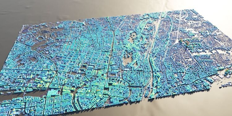
A new machine learning system can create height maps of urban environments from a single synthetic aperture radar (SAR) image, potentially accelerating disaster planning and response.
Aerospace engineers at the University of the Bundeswehr Munich claim their SAR2Height framework is the first to provide complete—if not perfect—three-dimensional city maps from a single SAR satellite.
When an earthquake devastates a city, information can be in short supply. With basic services disrupted, it can be difficult to assess how much damage occurred or where the need for humanitarian aid is greatest.
“Being able to produce 3D from [synthetic aperture radar] alone would really be a revolution.” —Carl Pucci, EO59
Aerial surveys using lidar systems provide the gold standard for 3D mapping, but such laser-ranging systems are expensive to buy and operate, even without the added logistical difficulties of a major disaster.
Remote sensing is another option, but optical satellite images are next to useless if the area is obscured by clouds or smoke.
Synthetic aperture radar, on the other hand, works day or night, whatever the weather. SAR is an active sensor that uses the reflections of signals beamed from a satellite toward Earth’s surface—the “synthetic aperture” part comes from the radar using the satellite’s own motion to mimic a larger antenna, to capture reflected signals with relatively long wavelengths. There are dozens of governmental and commercial SAR satellites orbiting the planet, and many can be tasked to image new locations in a matter of hours.
However, SAR imagery is still inherently two-dimensional, and can be even trickier to interpret than photographs. This is partly due to an effect called radar layover where undamaged buildings appear to be toppling toward the sensor.
“Height is a supercomplex topic in itself,” says Michael Schmitt, a professor at the University of the Bundeswehr Munich. “There are a million definitions of what height is, and turning a satellite image into a meaningful height in a meaningful world geometry is a very complicated endeavor.”
Schmitt and his colleague Michael Reclastarted by sourcing SAR images for 51 cities from the TerraSAR-X satellite, a partnership between the public German Aerospace Center and the private contractor Airbus Defence and Space.
The researchers then obtained high-quality height maps for the same cities, mostly generated by lidar surveys but some by planes or drones carrying stereo cameras. The next step was to make a one-to-one, pixel-to-pixel mapping between the height maps and the SAR images on which they could train a deep neural network.
The results were amazing, says Schmitt. “We trained our model purely on TerraSAR-X imagery, but out of the box it works quite well on imagery from other commercial satellites.” He says the model, which takes only minutes to run, can predict the height of buildings in SAR images with an accuracy of around 3 meters—the height of a single story in a typical building.
That means the system should be able to spot almost every building across a city that has suffered significant damage.
Pietro Milillo, a professor of geosensing systems engineering at the University of Houston, hopes to use Schmitt and Recla’s model in an ongoing NASA-funded project on earthquake recovery. “We can go from a map of building heights to a map of probability of collapse of buildings,” he says. Later this month, Milillo intends to validate his application by visiting the site of an earthquake in Morocco last year that killed over 2,900 people.
“There are a million definitions of what height is, and turning a satellite image into a meaningful height…is a very complicated endeavor.” —Michael Schmitt, University of the Bundeswehr Munich
But the AI model is still far from perfect, warns Schmitt. It struggles to accurately predict the height of skyscrapers and is biased toward North American and European cities. This is because many cities in developing nations did not have regular lidar mapping flights to provide representational training data. The longer the gap between the lidar flight and the SAR images, the more buildings would have been built or replaced, and the less reliable the model’s predictions.
Even in richer countries, “we’re really dependent on the slow revisit cycles of governments flying lidar missions and making the data publicly available,” says Carl Pucci, founder of EO59, a Virginia Beach–based company specializing in SAR software. “It just sucks. Being able to produce 3D from SAR alone would really be a revolution.”
Schmitt says the SAR2Height model now incorporates data from 177 cities and is getting better all time. “We are very close to reconstructing actual building models from single SAR images,” he says. “But you have to keep in mind that our method will never be as accurate as classic stereo or lidar. It will always remain a form of best guess instead of high-precision measurement.”
In the chaos following a major earthquake, even a best guess could be better than nothing.
From Your Site Articles
Related Articles Around the Web


