Road surface information plays an essential role across multiple sectors, influencing everything from transportation safety to economic growth and environmental sustainability. Knowing whether a road is paved or unpaved can impact decision-making for route planning and emergency responses.
For instance, unpaved roads, especially when poorly maintained or affected by weather, increase the risk of accidents. Emergency services need accurate road surface information to choose the safest and most efficient routes, especially in regions with limited infrastructure.
Beyond safety, this data is also key to optimizing supply chains, supporting agricultural operations, and improving industrial logistics. Poor road conditions can lead to delays, higher transportation costs, and reduced efficiency, hindering economic development.
For navigation tools such as Google Maps, OpenStreetMap (OSM), and GPS systems, accurate road surface information is crucial, particularly in rural or underdeveloped areas. By enhancing the precision of navigation systems, road surface data improves both safety and efficiency on a global scale.
Recent advances in geospatial technology, driven by companies like Microsoft and Google, have promoted global mapping. Their efforts have enhanced the mapping of buildings and roads, particularly in underserved areas.
However, mapping is only the first step. Adding detailed information, like road surface types, improves the accuracy and usefulness of mapping data. Enriching OpenStreetMap (OSM) with these attributes makes it a more valuable tool for decision-making and supporting services worldwide.
Currently, only 33% of roads in OSM have surface type information, with a larger gap in developing regions. To tackle this issue, HeiGIT has released a global dataset on road surface types (paved or unpaved), contributing to humanitarian efforts, urban planning, and economic development.

The dataset has been meticulously curated with the help of big data, machine learning and geospatial analysis. The team has made significant strides in improving global road surface classification using cutting-edge deep learning techniques. A major challenge was posed by the diversity of road imagery, especially from crowdsourced platforms like Mapillary, which provides vast street-view images worldwide.
To produce a robust training dataset, the team organized a mapathon in July 2023 using the HeiGIT CrowdMap web application. Thirty volunteers came together and labeled 20,000 random Mapillary images from 39 countries in sub-Saharan Africa, classifying them as “paved,” “unpaved,” or “bad imagery.” This labeling process created a reliable training set for the model.
Along the way, the team uncovered important trends in both urban and rural infrastructure related to global road surface data and Mapillary coverage. Mapillary’s global coverage remains limited, with only 3.48% of OpenStreetMap (OSM) roads covered on average. Urban areas show better coverage at 8.88%, while rural regions fall behind with just 2.65%.
However, critical roads like motorways and trunks have significantly higher coverage, reaching 45%, and cities in Western Europe, North America, and Australia boast coverage rates as high as 70%.
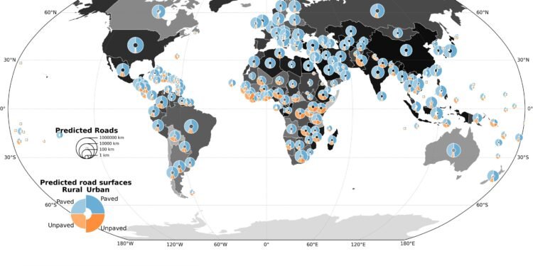
In terms of global road surface trends, the analysis revealed notable differences between urban and rural areas. In most urban regions, paved roads make up 60%–80% of the network. In contrast, rural areas, especially in Africa and Asia, display much more variety in road surface types. Paved road coverage in these regions drops below 40%, with countries like Pakistan, Nepal, Rwanda, and Mozambique standing out for their lower paved road ratios.
The study also showed a strong correlation between road infrastructure and development levels, with countries that have higher Human Development Index (HDI) scores generally featuring more paved roads. Lower-HDI regions, particularly in rural areas, showed greater variation in surface quality.
The analysis also includes a visual map that illustrates road surface conditions and the extent of data available in OSM. Developed regions like North America and Europe are well-documented, with mostly paved roads, while regions in Africa, South America, and parts of Asia have more unpaved roads and less comprehensive surface data.
As road infrastructure remains a critical metric for socio-economic development, our global road surface dataset will provide valuable insights, helping to build a more connected and resilient world. The generated dataset is openly available in the The Humanitarian Data Exchange and as a preprint on the arXiv server. This enables further analysis in geospatial applications and computer vision modeling.
Ultimately, our road surface dataset is an essential resource for researchers, planners, and humanitarian organizations, bridging the gap in global infrastructure data and supporting goals related to transportation safety, economic growth, and environmental protection.
More information:
Sukanya Randhawa et al, Paved or unpaved? A Deep Learning derived Road Surface Global Dataset from Mapillary Street-View Imagery, arXiv (2024). DOI: 10.48550/arxiv.2410.19874
arXiv
Provided by
HeiGIT gGmbH
Citation:
Paved or unpaved? Dataset can improve road surface data for transportation, safety and economic development (2024, November 14)
retrieved 14 November 2024
from https://techxplore.com/news/2024-11-paved-unpaved-dataset-road-surface.html
This document is subject to copyright. Apart from any fair dealing for the purpose of private study or research, no
part may be reproduced without the written permission. The content is provided for information purposes only.


